
ROOTS
A tour exploring some of the natural and human stories that have helped shape Toronto.
WALK TIME: 65 Minutes
Click the link below to launch the Audio Walk for mobile devices.
LOCATIONS


Potter’s Field (Former Paupers Cemetery)
2 Bloor Street West
While the German Consulate is located high above Yonge and Bloor in the tower on the northeast corner, Toronto’s first public non-denominational cemetery was located here on the northwest corner. Known as Potter’s Field, it began in 1826 and by 1855 had around 6700 burials, often some of the city’s poorest people and victims of typhoid, cholera and other diseases of the day. By then it was near capacity, the town had grown around it and the cemetery closed. Plans were made to move it to a less central location. Relatives had 20 years to remove their loved ones’ bodies and those not claimed were moved to the Necropolis in Cabbagetown or the then-new Mount Pleasant Cemetery. It’s likely, though, that some bodies were missed in the process.
Note the clock sculpture here by the American artist Wendell Castle, installed in 1988. At this meeting point of two subway lines and two major Toronto streets, it’s possible to truly say “meet me under the clock”.


Bud Sugarman Park
955 Yonge Street
Called the “unofficial mayor of Yorkville,” Budd Sugarman was the namesake of this small park along Yonge Street. A long-time merchant in the neighbourhood, he was an important figure in preserving the neighbourhood’s character and in establishing the Village of Yorkville Park. This spot affords a good view of Yonge Street as it dips alongside Ramsden Park and Rosedale subway station, a subtle trace of buried Castle Frank Brook below. Ramsden Park itself was originally a Victorian brickworks, its yellow clay giving Yorkville buildings and homes their distinctive colour.
Yonge Street was named after George Yonge, a friend of Ontario’s first governor general John Graves Simcoe. Yonge never visited Toronto and a more appropriate name might be Berczy Street, as William Berczy was an early German pioneer, sometimes considered a co-founder of Toronto, who helped clear what became the settlement of York and built fifteen miles of Yonge Street starting at Eglinton.


Severn Creek Park
100 Rosedale Valley Road
Note: Not Wheelchair Accessible
This is Severn Creek Park. It feels like a secret place, especially when accessed by the staircase leading down from Crescent Road, just east of the subway entrance. The forested staircase leads to a wide expanse of pleasant lawn and wooded ravine walls with Rosedale mansions perched on top. Down here it’s possible to get a sense of the creek, now buried, that flows below and to see how Rosedale station was built into the ravine walls. It was one of the original stations when the subway opened in 1954, designed by Toronto modernist architect John B. Parkin and historically designated. The hidden creek is now called Castle Frank Brook but the park’s name is an homage to its previous names of “Brewery Creek” or “Severn Creek,” after John Severn, one of the early village of Yorkville aldermen, who operated a brewery in this area, along the stream, beginning in 1835.
Walk the park south, following the buried creek towards Rosedale Valley Road, past a coach house that once served the mansion at the top of the ravine. The creek eventually empties into the Don River a few kilometers southeast of here, connecting this valley with Toronto’s vast ravine network.


The Studio Building
25 Severn Street
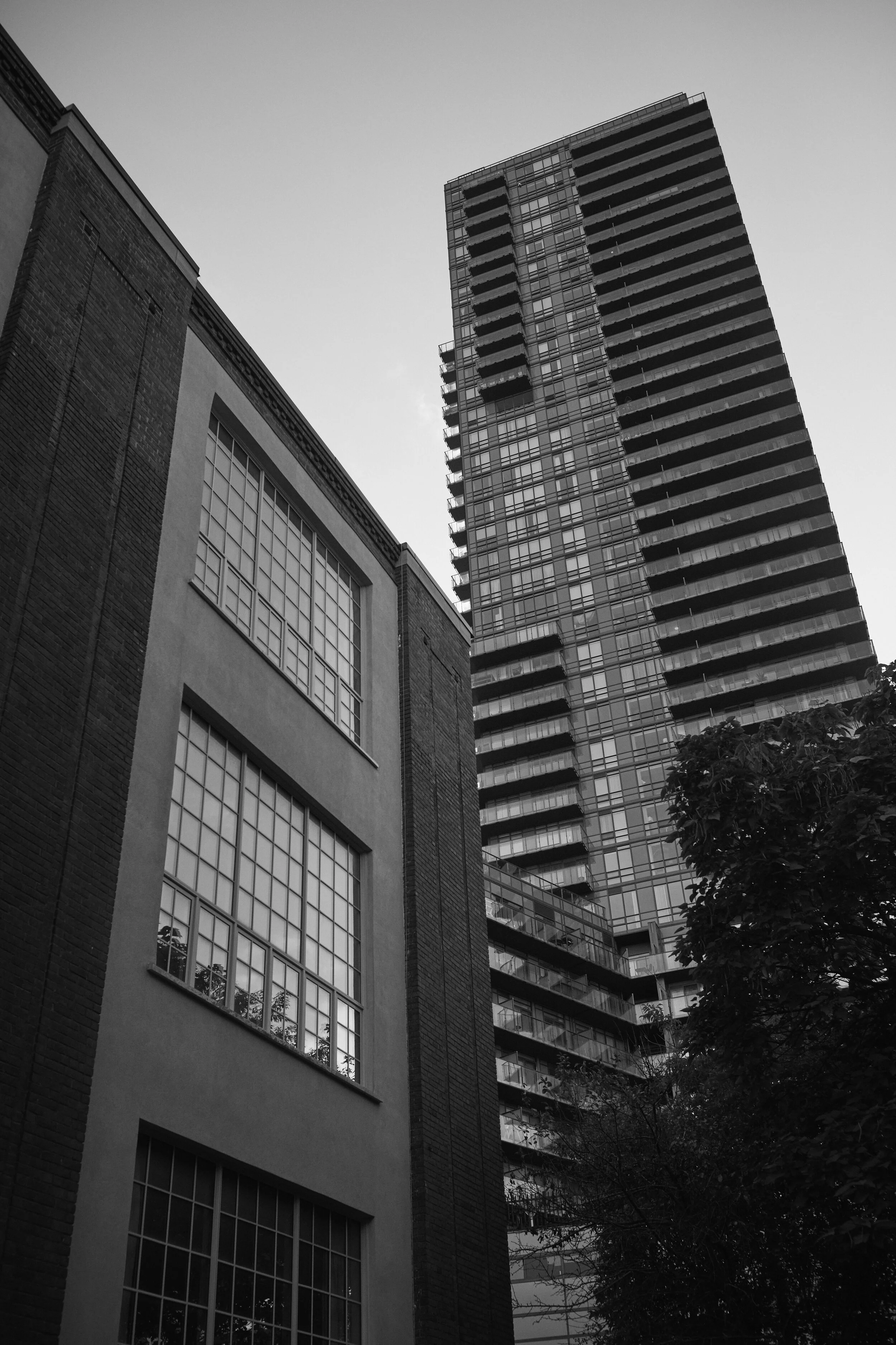
The studio building is a quintessentially urban structure but imagine it’s 1914, when it was built. There were no skyscrapers, the subway did not exist, and Severn Street, this stub of a road the building is located on, ran right up to Yonge Street. Facing north with big windows to allow in a flat, even light, the building was co-founded by Group of Seven member Lawren Harris and was meant to be a place where artists could live and work affordably.
Various members of the Group of Seven lived and worked in this bucolic setting. Tom Thomson, an associate of the collective, eventually used a refurbished utility shed out back during the winters, often snowshoeing down Rosedale Valley at night. The shed was moved and today can be visited on the grounds of the McMichael Gallery in Kleinberg.
The valley Thomson snowshoed was much different from the one you see today. Apart from burying Castle Frank Brook, the ravines of Toronto have been filled with infrastructure, some hidden and some visible, like roads, railways and massive underground trunk sewers.


DTAH Architects
50 Park Road
Toronto and Ontario experienced a massive boom after World War II with returning veterans and their families needing housing, the economy at full power and immigration starting to rapidly grow the country. Though sometimes known as a city of Victorian architecture, this boom meant that Toronto saw an incredible amount of mid-century modern building take place.
Nestled into the side of the Rosedale valley wall here is the former Ontario Association of Architects headquarters, currently the home of DTAH, an architecture, landscape and urban design firm. Designed by the modernist firm John B Parkin and Associates and opened in 1954, the same year the nearby subway was completed, it’s a bold statement from the era of bold modernism and representative of the optimism of the day. This building was most certainly influenced by the Bauhaus school in Germany, as was the apartment building next door with its glass wall and functional design.
Walking up Park Road, the transition from lush valley lands to a busy urban landscape is one of the most dramatic and abrupt changes in the city.


The 519
519 Church Street
Barbara Hall Park and the 519 Community Centre are arguably the town square of the Church-Wellesley Village. Named after former Mayor Barbara Hall, a supporter of the LGBTQ community throughout her public life, the park as well as the 519 building were once home to the Granite Club. One of the club buildings was destroyed by fire in 1913 and its foundation can still be found at the back of the park by the AIDS Memorial, itself begun as a temporary installation in the late 1980s but made permanent in 1993.
After the Granite Club moved, the building you see today, with its second-floor ballroom, housed the German Harmony Club until 1939 when it moved to Sherbourne Street. Later the building became the Ulster Athletic Club, then the headquarters for the 48th Highlanders. At risk of demolition in the mid-1970s, the building was turned into a City of Toronto community centre that ultimately, and not without some controversy, offered some of the first gay programming in the city.
During Pride, the park becomes an outdoor discotheque, and Church Street closed to cars, one of the biggest queer pride celebrations and on the scale of the annual Christopher Street Day Pride events in Berlin.


Phoenix Concert Theatre
410 Sherbourne Street
The Phoenix Concert Theatre here on Sherbourne Street does seem like an odd place for a club venue but this location has a long history as a social and cultural gathering spot. By the 1950s, after a stint in the building that houses the 519 Community Centre on Church Street, the German-Canadian Club Harmonie was a restaurant and bar, with oom-pah bands playing in the ballroom as well as a community meeting spot. For a while, Club Harmonie downsized to a smaller portion of the building while the ballroom became a dinner theatre until 1984 when the entire property was transformed into a legendary Toronto nightclub called The Diamond.
A dance club with occasional concerts, it became a well-known hipster hotspot, introducing new music to Toronto and becoming a hub for various subcultures as well as an occasional LGBTQ venue. It hosted well-known touring acts including small performances by superstars like Pink Floyd and David Bowie.
In the early 1990s the club changed hands and became the Phoenix and has operated for the last 30 years.


Allan Gardens + Conservatory
19 Horticultural Avenue
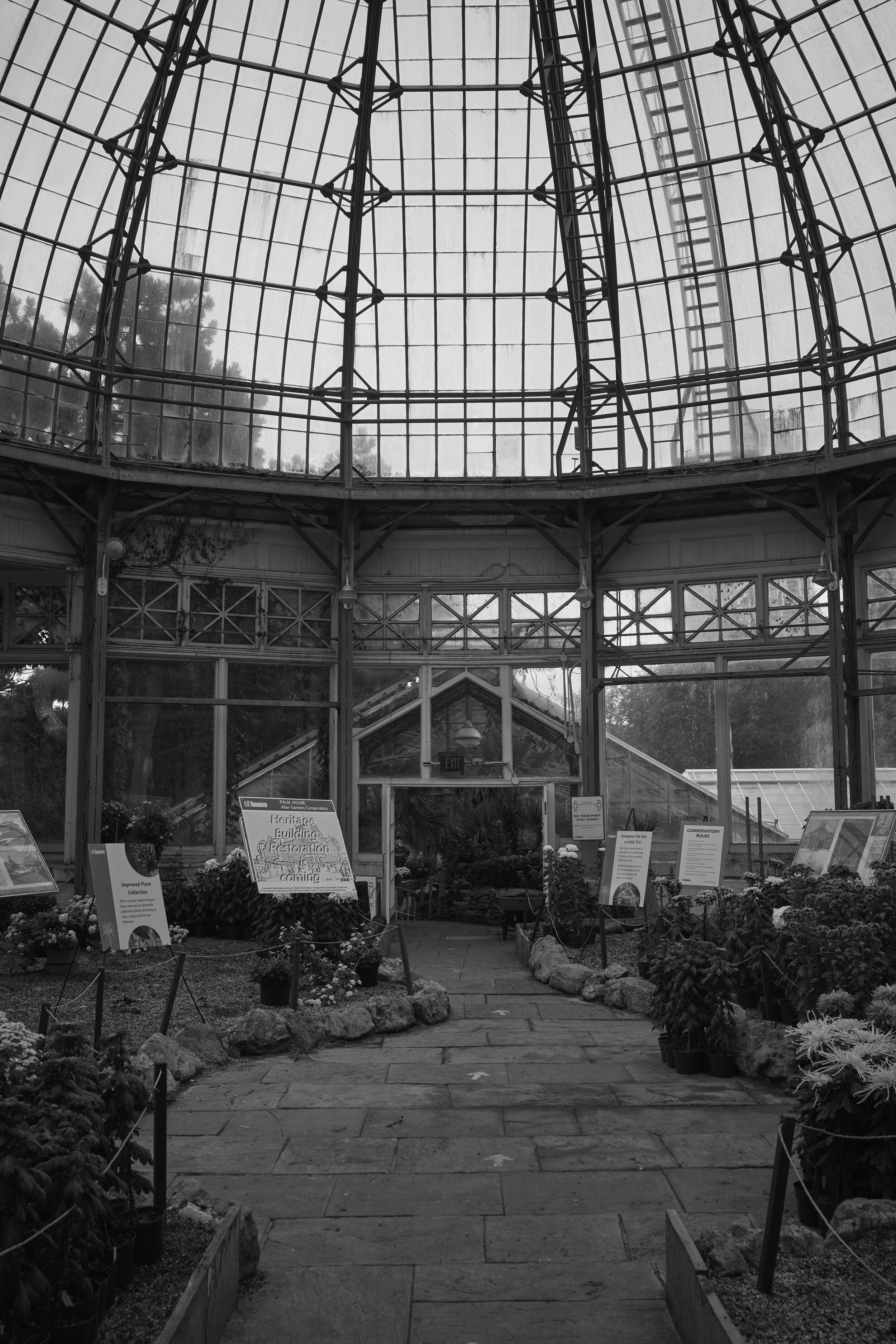
This wonderful conservatory, known as the Palm House, was built in 1909. Over the decades more greenhouses were added to it and now it’s a wonderful labyrinth of flowers, palms, tropical vines, cacti, succulents and even a turtle pond. The last greenhouses were installed in the mid-2000s when they were moved from their original location on the University of Toronto campus on the northwest corner of Queen’s Park and College Street, making way for a new school building there. It’s a great place to visit on a winter day.
This Park was donated to the Toronto Horticultural Society by its namesake and Toronto’s eleventh mayor, George William Allan, in 1858, and assumed by the City of Toronto the following decade. It’s one of the oldest parks in the city and today is often the site of LGBTQ events given its proximity to Church Street.
Apart from the village and town clusters, in the mid 1800s Toronto as we know it today was largely made up of estates owned by wealthy families. George William Allan’s father, William Allan, owned the estate where Allan Gardens and the surrounding neighbourhood are now and named it Moss Park. Like most of the estates, it was later subdivided and streets were laid, but the Moss Park name lives on in the nearby neighbourhood to the southeast.


The First Evangelical Lutheran Church
116 Bond Street
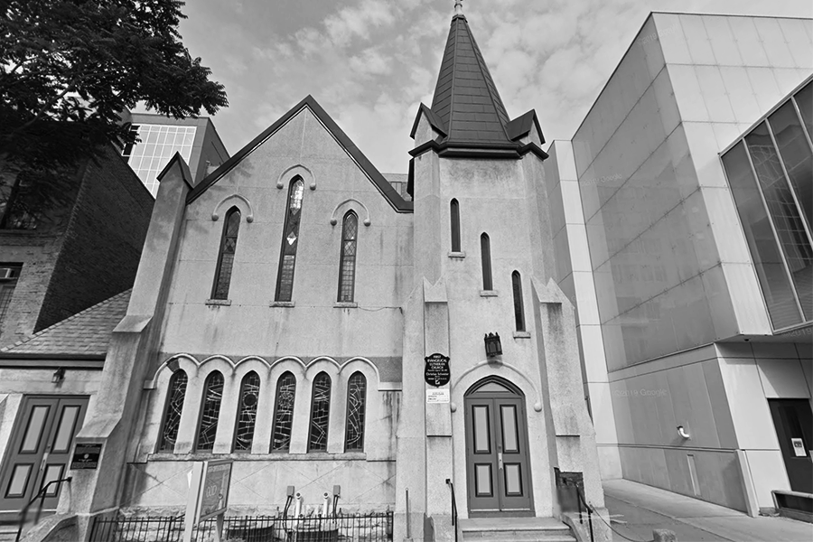
Here at 116 Bond Street is the First Evangelical Lutheran Church, founded in 1851, the oldest Lutheran congregation in Toronto, still holding services in German. Formed by a small number of German Lutheran families in Toronto, the current building was opened in 1898 on the site of the original simple frame church, and over the decades the church amalgamated with another Lutheran congregation and saw new additions to the community with immigrants from Germany and Eastern Europe after World War II. First Lutheran is Toronto’s Lutheran mother church and helped found other Lutheran congregations in the Finnish, Hungarian, Latvian, Lithuanian, Estonian and Swedish communities.
Bond forms part of the Ryerson University’s evolving urban campus and is a particularly Torontonian blend of old and new. At the top of the street is the Eugene O’Keefe house, named after a successful brewer, and the street is also home to the Ryerson Image Centre, with its undulating lit façade at night, as well as remodeled warehouse buildings. Saint George’s Greek Orthodox Church is here as well and is the mother church for Toronto’s Greek diaspora, but the building was previously Holy Blossom Temple before it relocated to Bathurst Street. Sheikh Deedat Mosque, closer to Dundas, rounds out this most spiritual of Toronto streets.


Yonge-Dundas Square
1 Dundas Street East
Yonge Dundas Square is the commercial heart of Toronto, sometimes unfairly called “Toronto trying to be Times Square,” Many big cities have a square or intersection where the neon and giant video billboards seem to be feral, as they do here. In the 1990s there was a desire to create a new, large public space in downtown Toronto as Nathan Phillips Square at City Hall was the only real open space. The design competition was won by Brown + Story Architects, the commercial buildings here previously were razed and the square officially opened in 2002.
Look up on the east side of the square to see the Sam the Record Man neon sign atop the Toronto Public Health building, moved here after the famous record store closed on Yonge Street a few blocks north.
The square’s creation opened up a new, expansive view of the Eaton Centre, Toronto’s downtown mall and office complex that opened in 1977. Created on land owned by the now-defunct Eaton’s department store chain, the complex was designed by German-Canadian architect Eberhard Zeidler and modelled after the Galleria Vittorio Emanuele II in Milan, Italy. The design was ultimately required to respect the Church of the Holy Trinity on the west side of the building as well as Old City Hall. Today it’s one of the, if not the, most visited attractions in Toronto.